
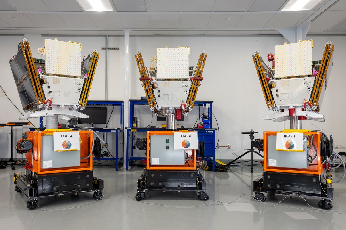
FireSat is a rare climate-tech story where the useful promise is easy to understand: find the fire while it is still small.
Google says three new FireSat satellites have launched, expanding a wildfire-detection network that uses purpose-built infrared sensors and AI to spot early-stage fires. Muon Space, which builds and operates the satellites for nonprofit Earth Fire Alliance, says the first three operational spacecraft contacted ground operators within 120 minutes of deployment and are healthy as commissioning begins.
GearPulse’s view: this matters because wildfire technology usually arrives in the public conversation after the sky is already orange. FireSat is trying to move the timeline earlier, closer to the first smoke column, when a few minutes and a sharper location can still change the response.
It also connects to a broader GearPulse thread: useful AI is often most convincing when it disappears into infrastructure. The same idea showed up in our recent Google Steel River solar-storage piece. The public headline is AI. The real value is whether the system makes a difficult physical-world operation less blind.
What launched
Muon Space announced on July 7 that the first three operational satellites for Earth Fire Alliance’s FireSat constellation launched aboard SpaceX’s Transporter-17 mission from Vandenberg Space Force Base. These follow a Protoflight spacecraft launched in March 2025.
Google’s new post says the pilot mission demonstrated the ability to detect early-stage wildfires as small as 5 x 5 meters and had already spotted small, low-intensity blazes that existing satellites missed. Muon adds that each new satellite carries a six-channel multispectral infrared payload designed to see through smoke and clouds.
| FireSat detail | Confirmed source-backed claim | Why it matters |
|---|---|---|
| First operational batch | Three satellites launched in July 2026 | The system is moving beyond a single demo spacecraft. |
| Prototype history | Protoflight launched in March 2025 | There is on-orbit experience behind the new batch. |
| Detection target | Fires as small as 5 x 5 meters | Earlier detection is the whole practical point. |
| Near-term cadence | At least twice-daily revisit across fire-prone regions | Useful, but not yet the final global promise. |
| Longer-term goal | Hourly global revisit by 2029, with fuller constellation growth after that | The best version depends on many more satellites. |
| Google.org support | More than $15 million for early deployment | Philanthropic funding helped get the network started. |
The caveat is important. Three operational satellites do not equal the final FireSat vision. Google Research describes the full constellation as eventually providing updates every 20 minutes or less anywhere on Earth. Muon says the current batch creates baseline dedicated coverage and a path toward faster revisit times.
That makes this a beginning, not a finished safety net.
Why ordinary satellites were not enough
Existing satellite tools are powerful, but wildfire detection is a brutal job.
A fire can begin under smoke, near cloud cover, in rough terrain or in a region where ground sensors are sparse. Many satellite products were not designed primarily for tiny ignition detection. Some revisit too slowly. Some lack the resolution or thermal sensitivity to catch a small, cool fire before it grows.
FireSat is purpose-built for that gap. Google Research says the system combines high-resolution multispectral infrared imagery with AI that compares a current image with the prior thousand images of the same location, while also considering local weather and related factors. That is exactly the kind of job AI should be good at: not replacing firefighters, but scanning boring, repetitive, high-volume data for the anomaly that humans need to see quickly.
The personal hook is simple. If you have ever watched a local fire map refresh too slowly, you know the anxiety of stale information. A better satellite network will not stop bad winds, drought, fuel buildup or human error. It can make the first confirmed signal arrive sooner.
The operational question is trust
Fire detection is not a social app feature. False positives waste scarce response capacity. False negatives can become disasters. Slow alerts are almost as bad as missed alerts.
That is why the most interesting FireSat metric may not be the prettiest satellite image. It will be trust in the workflow: how fast the alert is delivered, how well local agencies can use it, how often the system misses or over-flags, and whether the data lands in tools firefighters already understand.
| Reader question | Current answer | What still needs proof |
|---|---|---|
| Can it see tiny fires? | Google and Muon cite 5 x 5 meter detection capability. | Performance across terrain, smoke, clouds and fire types. |
| Is it operational? | The first three operational satellites are in commissioning. | Routine service quality after commissioning. |
| Is coverage global yet? | No. Current coverage is a baseline for fire-prone regions. | Larger constellation deployment and long-term funding. |
| Will agencies actually use it? | Earth Fire Alliance is built around fire-community collaboration. | Integration into dispatch, incident command and local workflows. |
| Is AI the magic part? | AI helps compare imagery and detect anomalies. | The system still depends on sensors, cadence, validation and human decisions. |
That last line is the point. FireSat is not exciting because it says “AI.” It is exciting because AI is attached to a sensor network, a nonprofit mission, a satellite manufacturer and a practical use case with a clear human buyer: people trying to stop fires before they explode.
The limits should stay visible
Wildfire risk is not a detection-only problem.
Communities still need defensible space, grid hardening, controlled burns, land management, evacuation planning and enough crews to respond. A faster alert does not guarantee a faster aircraft, a safer road, a staffed fire station or favorable weather. The satellite can tell people what is happening. It cannot create capacity where capacity is missing.
There is also a data-access question. Google says the data can support emergency response and scientific work. The real-world impact will depend on who gets access, under what timing, in what format, and with what reliability guarantees. Climate-tech projects can look excellent in a demo and still struggle if the data product is hard to operationalize.
Still, the direction is promising. Wildfire response is full of uncertainty. A purpose-built detection layer that sees smaller ignitions and refreshes more often would give firefighters a better starting point.
Bottom line
FireSat is compelling because it is not trying to make wildfire response glamorous. It is trying to make it earlier.
Three new satellites will not solve the fire crisis. They do, however, move a Google-backed, Earth Fire Alliance-led and Muon-built system from proof-of-concept toward daily operations. If the constellation scales and the alerts prove trustworthy, FireSat could become one of the more practical examples of AI in climate resilience: less hype, more minutes returned to people on the ground.
GearPulse’s read: the best version of this project is not an AI demo. It is a quieter future where the first reliable wildfire signal arrives before everyone can smell it.