A powerful earthquake is still a geology event first. But the response now starts with software.
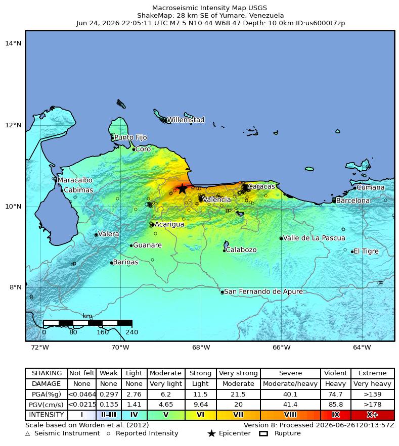
USGS lists the Venezuela quake as a reviewed magnitude 7.5 event, 28 km southeast of Yumare, at 22:05:11 UTC on June 24, 2026. The event was shallow, about 10 km deep, and carried a red PAGER alert, the USGS system used to estimate likely human and economic impact. Mobilissimo reported that Android phones sent warnings before the strongest shaking reached some users.
That is the part worth unpacking. Earthquake mitigation is increasingly a stack: sensors, phones, maps, models, alerts, and human action.
What happened
| Detail | USGS event data |
|---|---|
| Magnitude | 7.5 |
| Location | 28 km southeast of Yumare, Venezuela |
| Time | June 24, 2026, 22:05:11 UTC |
| Depth | About 10 km |
| USGS status | Reviewed |
| PAGER alert | Red |
A red PAGER alert does not mean USGS has counted final losses. It means the modeled impact is serious enough that emergency managers and humanitarian responders should pay close attention. ShakeMap adds another layer by estimating where shaking was strongest, which helps responders prioritize inspections, infrastructure checks, and public messaging.
How phone alerts work
Google’s Android Earthquake Alerts System turns a huge number of phones into a distributed sensing and alert network. Phones have accelerometers. When enough phones in an area detect shaking patterns that look like an earthquake, Google’s system can estimate the event and send alerts to Android users who may feel shaking.
In parts of the U.S. West Coast, Android also distributes alerts from ShakeAlert, a dedicated seismic-sensor network. Globally, the phone-based system is especially important in places where dense public seismic infrastructure is expensive or incomplete.
The physics is simple but unforgiving: fast, less-damaging P-waves arrive before stronger S-waves. If a system detects the first waves quickly enough and the user is far enough from the epicenter, it can deliver seconds of warning.
Seconds sound small until you know what to do with them.
What the technology can and cannot do
| System | Useful for | Limitation |
|---|---|---|
| Android earthquake alerts | Fast user warnings where phone coverage is dense enough. | Warning time depends on distance, device data, network conditions, and detection confidence. |
| ShakeMap | Rapid estimate of shaking intensity by area. | It is a model that updates as more data arrives. |
| PAGER | Early estimate of likely human and economic impact. | It is not a final damage assessment. |
| Local emergency systems | Evacuation, rescue, inspections, public instructions. | Depends on preparedness, communication, and trust. |
The key caveat is that phone alerts are mitigation, not prediction. They do not know an earthquake is coming before it starts. They detect an earthquake that has begun and try to beat the damaging waves to people farther away.
Why this matters beyond Venezuela
The Venezuela quake is a reminder that earthquake safety is becoming more unevenly distributed by technology access. A person with an Android phone, location services, connectivity, and alert settings enabled may get a few seconds to drop, cover, and hold on. Someone without that setup may not.
That does not make phone alerts a replacement for building codes, drills, hardened infrastructure, public sirens, radio, or local emergency management. It makes them a useful extra layer.
Google Research says Android Earthquake Alerts was built to detect earthquakes, deliver warnings, and build user trust through successful alerts. Trust is the hard part. False alarms, missed alerts, and confusing messages can make people ignore the next warning. Clear instructions matter as much as fast detection.
Bottom line
The Venezuela earthquake shows the value and the limits of alerting technology. Android phones can extend earthquake early warning to places where traditional sensor networks are thinner. USGS ShakeMap and PAGER can help responders understand where the risk is likely highest. Together, they turn raw shaking into faster decisions.
But the technology only buys time. The life-saving part is what people, buildings, and emergency systems do with those seconds.