
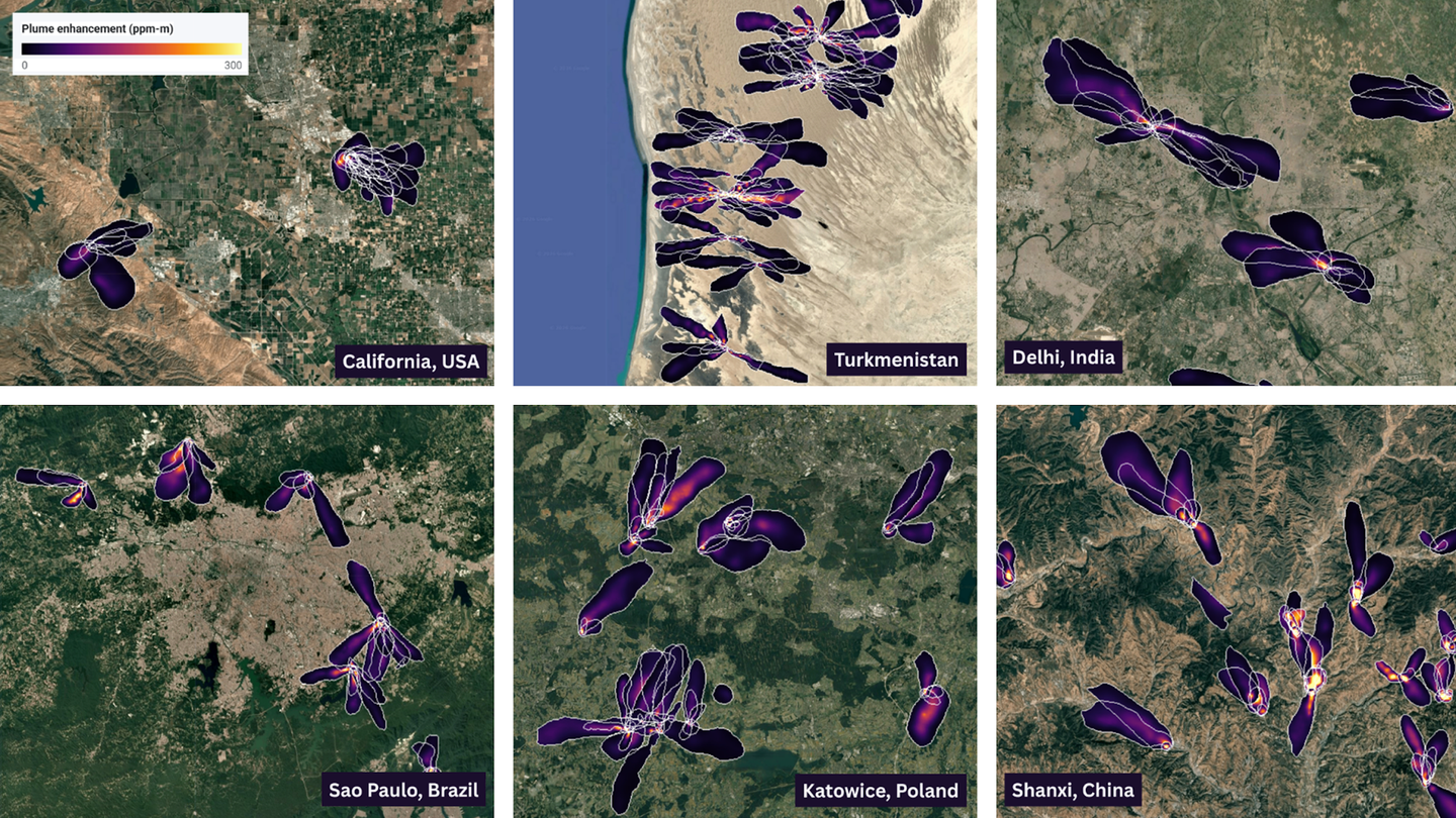
Methane is an unusually awkward emissions problem: it is invisible, transient and often spread across facilities nobody is watching closely. A new Google Research and NASA Jet Propulsion Laboratory project, MAPL-EMIT, makes that search less dependent on someone manually combing satellite scenes. It is a meaningful upgrade in the first step of climate work—finding a plausible source—rather than a machine-issued verdict about exactly who is responsible or what must be done next.
The model works on imagery from NASA’s Earth Surface Mineral Dust Source Investigation (EMIT), an imaging spectrometer on the International Space Station. EMIT was built to study mineral dust, but its many spectral bands can also reveal methane’s signature. NASA has already shown that capability can expose emissions from space; MAPL-EMIT applies a different kind of automation to the growing archive.
The authors trained a vision-transformer system on 3.6 million physics-based simulated plumes inserted into real EMIT scenes, then used it to estimate methane enhancement, trace a plume’s outline and identify its likely source location. The accompanying paper is the important reference here, not the attractive AI label: it sets out the approach and its evaluation. Google has also released the resulting data through Earth Engine, so the announcement is more useful than a closed demonstration.
What the model adds—and what it does not
The headline number is striking. Google says MAPL-EMIT captured 84% of expert-annotated plumes in its benchmark and found roughly 50% more plausible plumes across about 1,100 EMIT granules than an existing matched-filter approach. It also reports detections at 24 of the world’s 25 highest-emitting landfills examined.
Those are model-performance results, not a declaration that every highlighted site is a confirmed leak, a measured annual total or a regulatory violation. The paper and the release both acknowledge a familiar sensitivity trade-off: looking harder for weaker signals raises the risk of false positives, particularly over difficult terrain. MAPL-EMIT includes confidence information to help users decide where a result is strong enough to investigate.
| Layer | What MAPL-EMIT can provide | What still needs human or local evidence |
|---|---|---|
| Detection | A likely methane plume in a satellite scene | Whether it is a persistent, actionable event |
| Location | A probable source area, even in complex scenes | The facility, equipment and operator responsible |
| Quantification | Modelled atmospheric enhancement and plume data | A verified emissions inventory or repair outcome |
| Action | A prioritized place to inspect | The operational, legal and funding decision |
That distinction matters to GearPulse readers because data products are becoming part of physical infrastructure. A public map with a useful confidence signal can shorten the handoff between satellite operator, landfill manager, journalist, researcher or local regulator. It cannot replace field measurements, access to a site or a repair crew. But it can make those scarce resources less likely to be spent looking in the wrong direction.
Why the open release is the bigger product decision
Google has published a plume database and an Earth Engine viewer alongside model and inference resources. The Earth Engine catalog describes 60-metre enhancement maps and per-pixel plume probabilities, with data available through June 2026. In other words, the visible output is not simply a press-release map; it is material that a technically capable user can interrogate.
That openness is where the project earns scrutiny as well as credit. Users need to check the observation date, confidence category and spatial resolution before treating a colorful layer as an event report. A plume detected on a satellite pass may be intermittent; a nearby source may be hard to separate in an industrial cluster; and an absence of a detection does not prove an absence of emissions. Better interfaces can tempt people to read certainty into a heatmap that the underlying science does not promise.
Still, this is a more grounded application of AI than the usual generic assistant feature. It connects a model to a known sensor, a published method and data someone else can examine. That same insistence on measurable operating evidence is why our recent look at Google and Cathay’s contrail-avoidance trial focused on the gap between a forecast and an aviation decision. In methane monitoring, the equivalent gap is between a detected plume and a fixed source.
Bottom line
MAPL-EMIT does not make methane accountability automatic. It makes the search for methane sources more scalable, more inspectable and potentially more useful to the people who must decide what to inspect next. Its strongest claim is not that AI sees the invisible perfectly; it is that an openly released, confidence-scored satellite product can turn a vast archive into a better starting list for real-world action.